
Geography Grade 12 12 Sections44 Lessons365 Days
1.1. The Continental Drift Theory
Grade 12 Geography — Ethiopian Curriculum
Lesson Competencies
At the end of the lesson you will be able to:
Identify the continents that constituted Laurasia and Gondwanaland.
Explain the geological evidence that supports the Continental Drift theory.
Explain why Alfred Wegener’s continental drift theory was not easily accepted.
Describe how the continental drift theory and Plate Tectonics are related.
Key Terms
Continental Drift
The theory that continents have moved over geological time across the Earth’s surface.
Pangaea
A supercontinent that existed about 300 million years ago, containing all of Earth’s landmasses.
Laurasia
The northern supercontinent formed when Pangaea split, comprising North America, Europe, and Asia.
Gondwanaland
The southern supercontinent formed when Pangaea split, comprising South America, Africa, India, Antarctica, and Australia.
Fossils
Preserved remains or traces of ancient organisms used as evidence for continental drift.
Plate Tectonics
The modern theory explaining how Earth’s lithosphere is divided into plates that move over the asthenosphere.
Video Lesson
Core Lesson: The Continental Drift Theory
Introduction
Dear learners,
Look at a map of the world. Have you ever noticed that the eastern coastline of South America looks like it could slide neatly into the western coastline of Africa, almost like two pieces of a torn piece of injera? For centuries, mapmakers and scholars noticed this strange fit but could not explain it. This lesson tells the story of a German scientist, Alfred Wegener, who used this simple observation to build one of the most important ideas in Earth Science: the Continental Drift theory.
Brainstorming Scenario
Imagine Abebe and Tigist, two Grade 12 students in Addis Ababa, are comparing a fossil chart from a Brazilian textbook with one from a South African textbook for a school project. They notice the exact same ancient fern fossil, Glossopteris, listed in both, even though a wide ocean now separates the two countries. How could the same plant have grown on two continents that are thousands of kilometres apart today? Keep this question in mind as you work through the lesson — by the end, you will be able to explain it yourself.
1. What is the Continental Drift Theory?
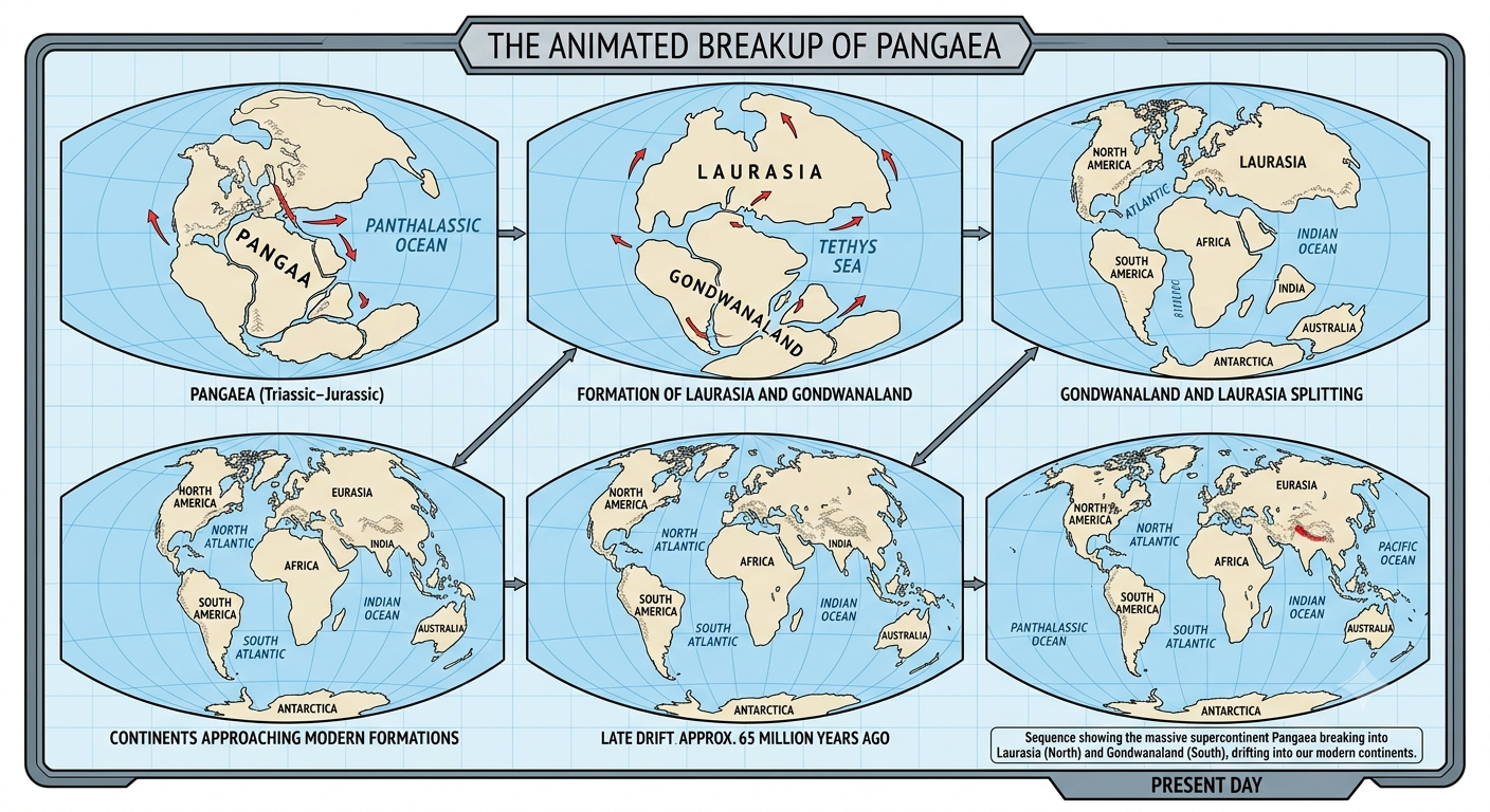
The Continental Drift theory states that all the continents were once joined together in a single giant landmass called Pangaea (meaning “all lands” in Greek), and that over hundreds of millions of years this landmass slowly broke apart and drifted to their present positions.
2. Alfred Wegener: The Father of Continental Drift
Alfred Wegener (1880–1930) was a German meteorologist and polar researcher — not a geologist. In 1912, while studying world maps, he proposed that the continents were once joined and had since drifted apart. He published his full argument in 1915 in his book “The Origin of Continents and Oceans.”
3. The Breakup of Pangaea
According to Wegener, about 300 million years ago Pangaea began to split into two large landmasses:
Laurasia (North)
Made up of present-day North America, Europe, and Asia.
Gondwanaland (South)
Made up of present-day South America, Africa, India, Antarctica, and Australia. Ethiopia sits on the African portion of what was once Gondwanaland.
These two supercontinents later broke apart further into the seven continents we recognise today.
4. Geological Evidence Favouring Continental Drift Theory
a) Coastline Similarity (The “Jigsaw Puzzle” Fit)
The coastlines of Africa and South America fit together almost perfectly, like two pieces of a puzzle, suggesting they were once joined.
b) Rock Type and Structural Similarities
Matching rock layers and ancient mountain ranges of the same age and structure are found on continents that are now far apart — for instance, mountain belts in Ethiopia’s basement rock share similarities with rock formations in Brazil and India, both former parts of Gondwanaland.
c) Fossil Evidence
Identical fossils of the same age are found on continents separated by oceans. The plant fossil Glossopteris and the reptile fossil Mesosaurus appear in Africa, South America, India, Antarctica, and Australia — animals and plants that could not have swum across an entire ocean.
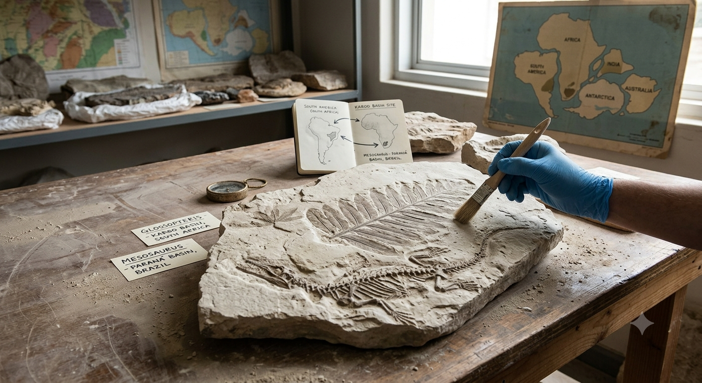
Evidence of ancient glaciers has been found in present-day hot regions such as parts of Africa and India, while thick coal deposits (which form in warm, swampy forests) have been found in the cold region of Antarctica. This only makes sense if these landmasses were once located at very different latitudes.
5. Why was Wegener’s Continental Drift Theory Rejected?
a) Wegener’s Profession
Because Wegener was a meteorologist and not a trained geologist, many geologists of his time dismissed his ideas as those of an outsider.
b) Geographical Bias of Data
Much of the early supporting evidence came from the southern continents (Gondwanaland). Scientists in Europe and North America, who dominated the field at the time, had less direct access to this data and were slower to accept it.
c) Lack of a Mechanism (The Biggest Problem)
Wegener could not explain what force was powerful enough to move entire continents through solid ocean floor. Without a believable mechanism, most scientists rejected the theory outright.
6. Legacy of Wegener’s Theory & The Discovery of Seafloor Spreading (1960s)
Wegener died in 1930 still defending his theory, decades before it was accepted. In the 1960s, scientists studying the ocean floor discovered seafloor spreading: new ocean crust is continuously created at mid-ocean ridges and spreads outward, pushing continents apart. This finally gave Wegener’s idea the missing mechanism.
7. Plate Tectonics Theory
Plate Tectonics is the modern theory explaining that the Earth’s rigid outer shell (the lithosphere) is broken into large moving plates that float on the semi-fluid asthenosphere beneath them. Ethiopia’s own Great Rift Valley and the Afar Depression, where three plates (Nubian, Somali, and Arabian) are pulling apart, is one of the best living examples of plate tectonics in action anywhere on Earth.
8. Relationship Between Continental Drift and Plate Tectonics
Continental Drift was the first idea that continents move; Plate Tectonics is the fully developed modern theory that explains how and why they move. Continental drift provided the observations and questions; plate tectonics, built on seafloor spreading and the study of the Earth’s plates, provided the answers. Today, plate tectonics is the unifying theory of modern geology, and continental drift is recognised as its historic foundation.
Illustration: The Breakup of Pangaea
Examples & Illustrations from Ethiopia
The Great Rift Valley
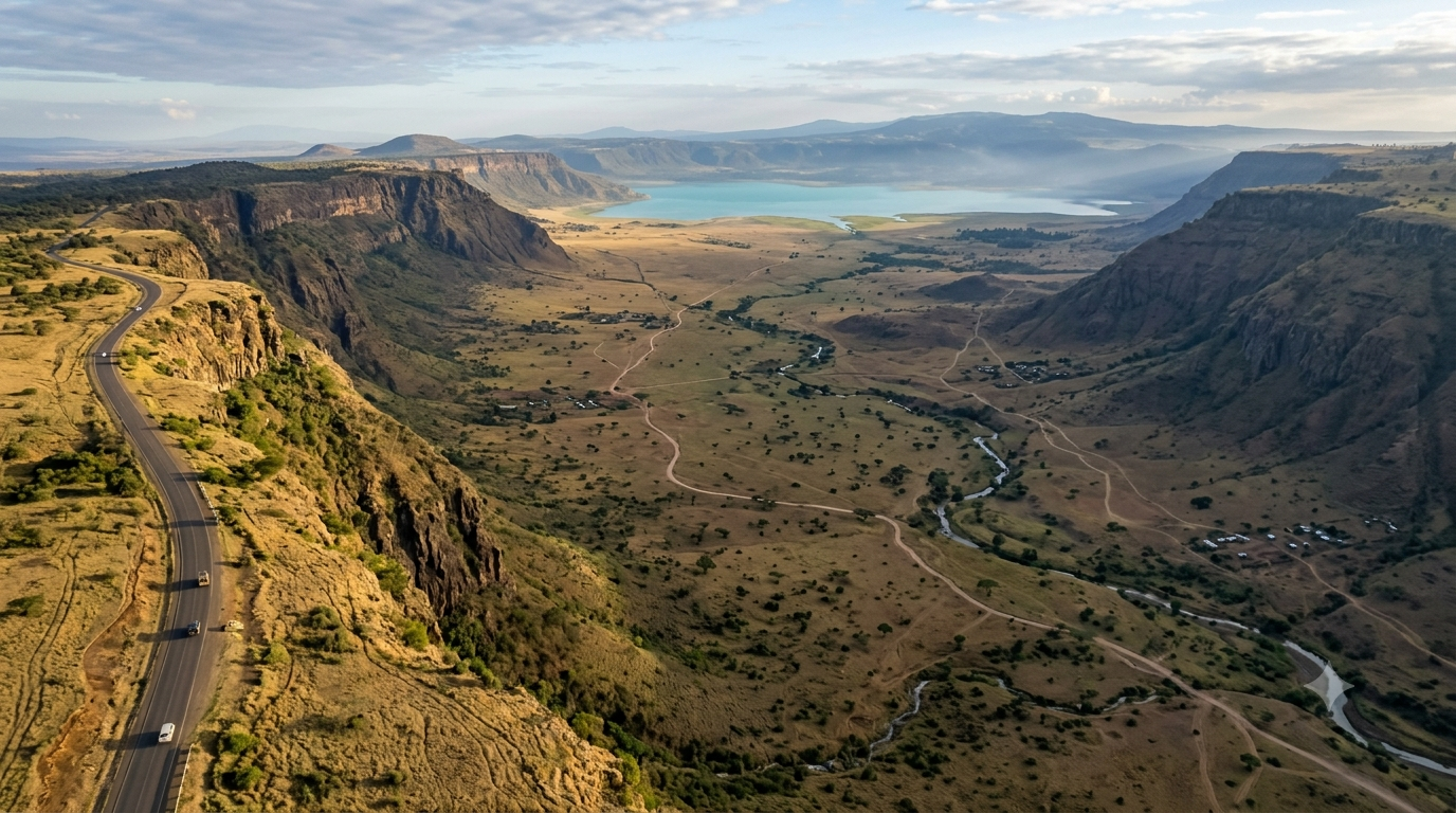
Running from the Afar Depression in the north to the Ethiopian Highlands and southward, Ethiopia’s Rift Valley is being slowly pulled apart today, at roughly the same speed your fingernails grow. It is direct, living proof that Earth’s crust really does move — exactly as Wegener predicted.
The Afar Triangle
In the Afar Depression, three tectonic plates (Nubian, Somali, and Arabian) meet at a “triple junction.” Scientists travel from all over the world, including Addis Ababa University’s Department of Earth Sciences, to study this rare site where a new ocean may one day form.
Ethiopian Basement Rocks
Ancient crystalline basement rocks found in southern Ethiopia and Kenya share the same age and structure as rocks found in Brazil, Madagascar, and India — all once joined together as Gondwanaland.
Classroom Analogy
Think of a fresh injera cooling on a mesob: as it cools and contracts, small cracks can appear and slowly widen. In a similar (though far slower) way, Earth’s crust cracks and the pieces drift apart over millions of years.
Game: Sort the Supercontinent
Drag each continent card into the basket where it belongs — Laurasia or Gondwanaland. On touch devices, tap a card to pick it up, then tap the basket to place it.
Continents
Laurasia
Gondwanaland
Interactive Activity 1: Know the Basics
Multiple-choice questions, from simple to more challenging.
Interactive Activity 2: Fill in the Blank — The Evidence Trail
Type the missing word or phrase for each statement about the evidence for continental drift.
Interactive Activity 3: Mixed Challenge
A mix of true/false, multiple-choice, and fill-in-the-blank questions on rejection of the theory and plate tectonics.
Lesson Summary
About 300 million years ago, all of Earth’s landmasses were joined in one supercontinent called Pangaea, which later split into the northern Laurasia (North America, Europe, Asia) and the southern Gondwanaland (South America, Africa, India, Antarctica, Australia).
Alfred Wegener proposed the Continental Drift theory in 1912, supported by matching coastlines, similar rock structures, shared fossils like Glossopteris and Mesosaurus, and paleoclimatic clues like glacial deposits and coal beds in unexpected places.
The theory was rejected for decades because Wegener was not a geologist, most evidence came from the southern continents, and above all he could not explain the force driving the movement.
The discovery of seafloor spreading in the 1960s solved this puzzle and gave rise to Plate Tectonics, the modern theory that fully explains continental movement — with Ethiopia’s own Great Rift Valley and Afar Depression standing as living evidence of the process today.
Assessment
Five quiz questions to check your understanding of the whole lesson.
Competency Checklist
Tick the box once you feel confident you can do each of the following: