
Geography Grade 12 12 Sections44 Lessons365 Days
1.3. Internal (Endogenic) Forces
Geography – Grade 12 (Ethiopian Curriculum)
Lesson Competencies
At the end of the lesson, you will be able to:
Describe the main sources of internal heat energy within the Earth and explain how this heat drives geological processes.
Identify the major internal forces and relate them to specific geological phenomena like plate tectonics, volcanism, and seismic activity.
Explain the concept of plate tectonics as a result of internal Earth forces, and provide examples of plate interactions.
Describe the characteristics of earthquakes including seismic waves, focus, epicenter, and measurement scales.
Identify major earthquake zones around the world including the Circum-Pacific Belt and Mediterranean-Asian Belt.
Define volcanism and distinguish between different types of volcanic features and eruption styles.
Classify volcanoes by activity level and shape, providing examples from around the world.
Describe intrusive landforms and explain how they are formed beneath the Earth’s surface.
Key Terms
Endogenic Forces
Internal forces originating from within the Earth that shape the planet’s surface through tectonic movements, volcanism, and earthquakes.
Plate Tectonics
The theory explaining the movement of Earth’s lithospheric plates driven by convection currents in the mantle.
Seismic Waves
Energy waves generated by earthquakes that travel through Earth’s interior (P-waves, S-waves) and along its surface (Love waves, Rayleigh waves).
Epicenter
The point on Earth’s surface directly above the focus where an earthquake originates.
Volcanism
All processes and phenomena associated with the eruption of molten rock, gases, and materials from Earth’s interior onto its surface.
Magma
Molten rock beneath Earth’s surface that becomes lava when it erupts.
Richter Scale
A logarithmic scale (0-9) used to measure the magnitude of earthquakes based on seismic wave amplitude.
Batholith
A very large, dome-shaped intrusive igneous rock formation that often forms the core of mountain ranges.
Ring of Fire
The Circum-Pacific Belt, a major area in the Pacific Ocean where ~80% of the world’s earthquakes occur.
Caldera
A large, basin-shaped depression formed after a magma chamber drains and the overlying volcanic cone collapses.
Video Lesson
Core Lesson
Introduction
Dear learners,
Imagine standing on what seems like solid, unchanging ground. Yet beneath your feet, tremendous forces are at work—forces so powerful they can build mountains, trigger earthquakes, and create volcanoes. These are the endogenic forces, internal forces that originate deep within our planet.
Today, we’ll explore a fascinating question: What if the Earth beneath us is not as solid as it seems? What if it’s a dynamic, ever-changing system powered by incredible heat from within?
Think About This:
You’re walking in the Great Rift Valley of East Africa. Suddenly, you feel a slight tremor beneath your feet. In the distance, you see Mount Erta Ale in Ethiopia glowing with molten lava. What forces created this valley? Why is there volcanic activity here? What’s happening deep inside the Earth?
1. Sources of Internal Heat Energy
The Earth is not a cold, dead rock. Deep within our planet, temperatures reach over 5,000°C at the core—hotter than the surface of the Sun! But where does this incredible heat come from?
A. Radioactive Decay
Deep in the Earth’s mantle and core, radioactive elements like uranium-238, thorium-232, and potassium-40 continuously break down. This process, called radioactive decay, releases enormous amounts of heat energy. It’s like having billions of tiny nuclear reactors inside the Earth, running for billions of years!
B. Primordial Heat
When Earth formed about 4.6 billion years ago, countless collisions between space rocks and asteroids generated tremendous heat. Some of this original heat—called primordial heat—is still trapped deep inside the planet, slowly escaping over geological time.
C. Gravitational Compression
The immense weight of Earth’s outer layers presses down on the interior, creating enormous pressure. This gravitational compression generates heat, much like how a bicycle pump gets warm when you compress air inside it.
How Heat Drives Geological Processes
This internal heat doesn’t just sit there—it creates convection currents in the semi-molten mantle. Hot material rises toward the surface, cools, and then sinks back down, creating a continuous cycling motion. These convection currents are the engine that drives plate tectonics, volcanism, and mountain building!
2. Plate Tectonics: The Grand Design
Earth’s outermost layer, the lithosphere, is broken into massive pieces called tectonic plates. These plates float on the semi-molten asthenosphere beneath them, constantly moving—though very slowly (only a few centimeters per year).
Earth’s Tectonic Plates

Major tectonic plates and their boundaries across the globe
Types of Plate Boundaries and Landforms
Divergent Boundaries (Moving Apart)
Plates move away from each other, creating gaps where molten rock rises to fill the space.
Examples:
- Mid-Atlantic Ridge: An underwater mountain range where new oceanic crust forms
- Great Rift Valley (East Africa): A continental rift where Africa is slowly splitting apart
Landforms Created: Rift valleys, mid-ocean ridges, volcanic islands
Convergent Boundaries (Colliding)
Plates crash into each other. The denser plate usually sinks beneath the lighter one in a process called subduction.
Examples:
- Himalayas: Formed by the collision of the Indian and Eurasian plates
- Andes Mountains: Created by oceanic plate subducting under continental plate
- Japanese Islands: Volcanic arc formed by ocean-ocean convergence
Landforms Created: Mountain ranges, deep ocean trenches, volcanic arcs, island chains
Transform Boundaries (Sliding Past)
Plates slide horizontally past each other, creating tremendous friction and stress.
Examples:
- San Andreas Fault (California): Pacific Plate grinding past North American Plate
Landforms Created: Fault lines, offset streams, linear valleys, earthquake zones
3. Earthquakes: When the Earth Shakes
An earthquake is the sudden release of energy in Earth’s crust, creating seismic waves that make the ground shake. Most earthquakes occur along plate boundaries where stress builds up over time.
Key Earthquake Terminology
Focus (Hypocenter)
The point of rupture below Earth’s surface where the earthquake originates.
Epicenter
The point on Earth’s surface directly above the focus. This is usually where the strongest shaking occurs.
Types of Seismic Waves
P-Waves (Primary Waves)
Body waves that travel through Earth’s interior. They compress and expand material like a spring. Fastest seismic waves; can travel through solids, liquids, and gases.
S-Waves (Secondary Waves)
Body waves that move material up and down or side to side. Slower than P-waves; can only travel through solids (not liquids).
Love Waves
Surface waves that move the ground side to side in a horizontal motion. Cause most of the damage during earthquakes.
Rayleigh Waves
Surface waves that create a rolling, circular motion like ocean waves. Slowest but very destructive.
Measuring Earthquakes: The Richter Scale
The Richter Scale measures earthquake magnitude (the amount of energy released) on a logarithmic scale from 0 to 9. Each whole number increase represents a 10-fold increase in amplitude and about 31 times more energy release!
Magnitude 2-3: Generally not felt, but recorded
Magnitude 4-5: Felt by people, minor damage
Magnitude 6-7: Can cause significant damage
Magnitude 8+: Great earthquake, massive destruction
Effects of Earthquakes
Building and infrastructure collapse
Fires from broken gas lines
Landslides and mudflows
Changes in groundwater flow
Tsunamis (from underwater earthquakes)
Ground rupture and fissures
Tsunamis: Giant Killer Waves
When an earthquake occurs underwater, it can displace massive amounts of water, creating tsunamis—giant waves that can travel across entire oceans at speeds up to 800 km/h. When they reach shallow coastal waters, these waves can grow to heights of 30 meters or more, causing devastating destruction.
Major Earthquake Zones
Circum-Pacific Belt (Ring of Fire)
Circles the Pacific Ocean, accounting for approximately 80% of the world’s seismic energy. Includes Japan, Philippines, Indonesia, New Zealand, western coasts of North and South America.
Mediterranean-Asian Belt
Extends from the Mediterranean through the Middle East, Himalayas, to Southeast Asia. Less active than the Ring of Fire, accounting for about 15% of seismic energy.
Mid-Oceanic Ridges and Rift Valleys
Zones of seismic activity along divergent boundaries. Example: Great Rift Valley of East Africa.
Benioff Zones
Areas where deeper focus earthquakes commonly occur. These zones dip down into the mantle at convergent boundaries where tectonic plates are subducting.
4. Volcanism: Fire from Below
Volcanism refers to all processes and phenomena associated with the eruption of molten rock (magma), gases, and other materials from a planet’s interior onto its surface. When magma reaches the surface, it’s called lava.
Features Related to Volcanoes
Vents
Pipe-like openings through which magma flows to the surface. Repeated eruptions build up cone-shaped volcanoes around the vent.
Fissures
Large, narrow cracks in the Earth’s crust through which molten materials spread out horizontally, forming extensive lava plateaus rather than cone-shaped mountains.
Classification by Activity Level
Active Volcanoes
Have erupted or are thought to have erupted within the last 500 years. Example: Erta Ale, Ethiopia—one of the world’s few permanent lava lakes.
Dormant Volcanoes
Currently inactive but have erupted historically and are likely to erupt again. Example: Mount Kilimanjaro, Tanzania—Africa’s highest peak.
Extinct Volcanoes
Not currently erupting and unlikely to erupt in the future. Example: Mount Zuqualla, Ethiopia.
Classification by Shape and Size
Shield Volcanoes
Broad, gently sloping volcanoes with a low profile. Formed by highly fluid, low-viscosity lava that flows easily and spreads out over large areas.
Example: Hawaiian Islands (Mauna Loa, Mauna Kea)
Stratovolcanoes (Composite Volcanoes)
Tall, steep-sided cones built up by alternating layers of lava flows and pyroclastic materials (ash, rock fragments). These are the most common type and have explosive eruptions.
Examples: Mount Fuji (Japan), Mount St. Helens (USA), Mount Vesuvius (Italy)
Cinder Cones
Small, conical hills built from cinder-sized pyroclastic fragments ejected from a single vent. Simplest type of volcano with steep sides.
Example: Parícutin (Mexico)
Volcanic Features
Craters
Bowl-shaped depressions at the summit of a volcano, formed by collapse or violent explosions.
Calderas
Large, basin-shaped depressions formed after a magma chamber drains and the overlying volcanic cone collapses. Much larger than regular craters.
5. Intrusive Landforms: Hidden Beneath
Not all magma reaches the surface. When magma cools and solidifies within Earth’s crust, it forms intrusive igneous rocks and creates various underground structures called plutonic features.
Batholith
A very large, dome-shaped intrusion of igneous rock. Batholiths often form the cores of major mountain ranges and are exposed only after millions of years of erosion.
Example: Sierra Nevada Batholith (California, USA)
Sill
A near-horizontal, sheet-like intrusion that forms when magma is injected between existing rock layers. Sills run parallel to the rock layers.
Dike
A vertical or near-vertical sheet of igneous rock formed when magma rises through cracks that cut across existing rock layers. Dikes run perpendicular to rock layers.
Intrusive vs. Extrusive Landforms

Cross-section showing both intrusive (underground) and extrusive (surface) volcanic features
Examples & Illustrations
The Ring of Fire: Earth’s Most Active Zone
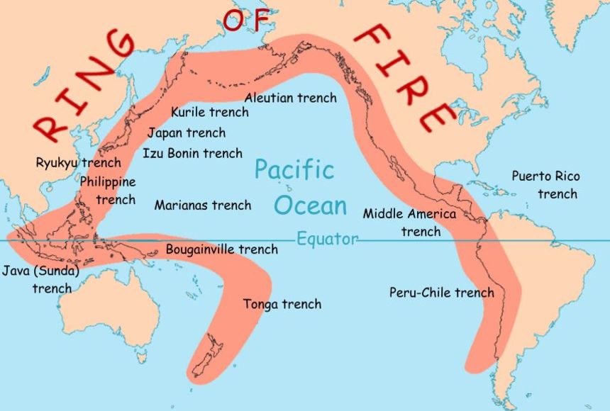
The Pacific Ring of Fire is a 40,000 km horseshoe-shaped zone that experiences:
- ~90% of the world’s earthquakes
- ~75% of the world’s active volcanoes
- Major tectonic activity due to subduction zones
- Countries affected: Japan, Philippines, Indonesia, Chile, USA (Alaska, California)
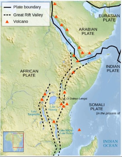
The Great Rift Valley: Africa Splitting Apart
The East African Rift System is a prime example of a divergent boundary on a continent. It stretches over 6,000 km from the Red Sea to Mozambique.
Key Features:
- Active volcanoes (Erta Ale, Ol Doinyo Lengai)
- Deep lakes (Lake Tanganyika, Lake Malawi)
- Escarpments up to 2,000 meters high
- Africa may split into two separate landmasses in millions of years!
The Himalayas: Continental Collision
The Himalayas are the world’s highest mountain range, formed by the collision of the Indian and Eurasian plates—a perfect example of a convergent boundary between two continental plates.
Timeline of Formation:
- 200 million years ago: India was part of the supercontinent Gondwana
- 140 million years ago: India began moving northward
- 50 million years ago: India collided with Asia, creating the Himalayas
- Today: The mountains are still rising ~5 mm per year!
Ethiopian Volcanoes: Living Examples
Erta Ale (Active)
Located in the Afar Region, Erta Ale is one of only six volcanoes worldwide with a persistent lava lake. It’s been continuously active since at least 1967, making it one of the most active volcanoes in Ethiopia.
Mount Zuqualla (Extinct)
A dormant or extinct stratovolcano in central Ethiopia with a beautiful crater lake at its summit. It hasn’t erupted in recorded history.
Mount Fentale (Dormant)
Located in the Main Ethiopian Rift, this volcano last erupted in the 1800s and is considered dormant but potentially active.
Activity 1: Multiple Choice Questions
Test your understanding of internal forces. Select the best answer for each question.
Activity 2: True or False
Determine whether each statement is true or false.
Activity 3: Mixed Challenge
Test your knowledge with a variety of question types.
Lesson Summary
Endogenic forces are internal forces originating from within the Earth, driven by internal heat from radioactive decay, primordial heat, and gravitational compression.
Plate tectonics explains how Earth’s lithosphere is divided into moving plates. Divergent boundaries create rift valleys and mid-ocean ridges, convergent boundaries form mountains and trenches, and transform boundaries create fault zones.
Earthquakes release energy along plate boundaries. Seismic waves include body waves (P-waves and S-waves) and surface waves (Love and Rayleigh waves). The Richter Scale measures earthquake magnitude on a logarithmic scale from 0 to 9.
The Circum-Pacific Belt (Ring of Fire) accounts for ~80% of global seismic energy, while the Mediterranean-Asian Belt accounts for ~15%.
Volcanism includes all processes of magma eruption. Volcanoes are classified by activity (active, dormant, extinct) and by shape (shield, stratovolcano, cinder cone).
Intrusive landforms like batholiths, sills, and dikes form when magma cools beneath Earth’s surface, creating plutonic igneous rocks.
Understanding endogenic forces helps us comprehend Earth’s dynamic nature and prepare for geological hazards like earthquakes and volcanic eruptions.
Assessment
Evaluate your understanding of the entire lesson.
Competency Checklist
Check off each competency as you master it: